Floods
The most basic description of a flood is that flood is a situation in which water temporarily covers land where it normally doesn’t. This water may come from the sea, lakes, rivers, canals, sewers or precipitation. The world maps of flooding at the Darthmouth Flood Observatory (DFO) shows that floods are not limited to specific areas, but are widespread.
Floods can bring misery to those that live in the area. Floods all over the world cause enormous damages every year such as loss of life or health, economic damages, damage to the natural environment and damage to cultural heritage sites or objects.
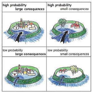
The consequences of flooding depend on the seriousness of the flood (height, speed, etc), the presence of people, economic activities, nature etc. and their vulnerability to floods. Flood risk is a combination of the probability of a flood event and its consequences. The Dutch national water authority “Rijkswaterstaat” uses this drawing below to explain the concept of risk. It shows the four categories of risk: high probability and large consequences being the most severe risk. How to define “high” and “large” forms part of the societal debate. Scientist work on quantifying both probability and consequences and develop strategies to reduce risks in a way that is acceptable to society.

Strategies to deal with flood risk can be directed to
- reducing the probability of floods for example by increasing dyke height,
- reducing the consequences of floods by flood-proving houses, providing flood shelters and generally improving flood preparedness,
- improving the recovery capacity of the community so they are able to rebuild their houses and economy after a flood,
- improve the adaptive capacity of the society so they are more able to adjust to changing circumstances.
The water resources management group does research on both flood prediction and flood risk management.
For information on floods contact Frans van der Ven, Olivier Hoes or Sandra Junier.